Annonces |
|
Volcan in eruption : Semeru - Volcanos| Oceania -
[29/07/2006]
Place : Java, Indonesia.
Type : stratovolcano.
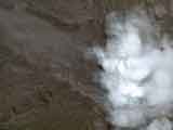
Description : The Semeru volcano, 12000 feet (3676 m) high, is in permanent eruption since 1967. Semeru is also the highest mountain of the Java area. This volcano produces several explosions per hour.
View on Google Maps |
|
|
|
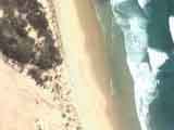
Koh Lanta 2006 - L'émission - VIP | New Caledonia -
[21/07/2006]
Place : Ile des Pins, Nouvelle-Calédonie, Océanie.
Description : L'émission Koh Lanta se déroule en 2006 sur l'île des Pins en Nouvelle Céladonie.
Surnommée "l'île la plus proche du paradis", c'est l'un des lieux les plus touristiques de l'archipel avec ses plages de sable fin et ses lagons.
Anectdote : un ouragan à faillit annuler l'émission cette année. |
|
View on Google Maps |
|
|
|
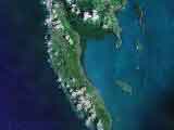
Ko Lanta - VIP | Thaïland -
[21/07/2006]
Place : Ko Lanta.
Description : "Koh" Lanta selon TF1 est île de la galère.
Ko Lanta de son vrai nom, est situé au Sud Ouest de la Thaïlande, on compte au total une cinquantaine d'îles. La plupart inhabitées.
15 d'entre elles sont classées Parc National.
View on Google Maps |
|
|
|
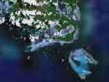
Manam volcano - Volcanos| Oceania -
[07/07/2006]
Place : Madang, New-Guinea.
Description : The Manam volcanic island is located close to the northern coast of New Guinea in the province of Madang. The volcano occupe all the central part of the island and some villages are located on the coasts. The Manam volcano is one of most active in New Guinea.
View on Google Maps |
|
|
|
Rangitoto Island volcano - Volcanos| Oceania -
[07/07/2006]
Place : Rangitoto island, Hauraki gulf.
Description : The Rangitoto island 850 feet (259 m) was a volcano in eruption 600 years before, it is extinct today. Rangitoto island is uninhabited (ten house), excursions are organized there. The Rangitoto island consists of volcanic rocks which did not prevented the development of vetetation.
View on Google Maps |
|
|
|
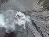
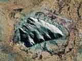
Bromo mount - Volcanos | Oceania -
[07/07/2006]
Place : Java, Indonesia.
Type : caldeira.
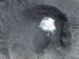
Description : The Bromo caldeira (7640 feet - 2329 m) is among the most beautiful in the world. This volcano is venerated by the hindouist people "Tengger" which live in this area. After ten years of sleep, the Bromo volcano awoke in March 1995. One more important working life then began, with, in particular, the eruptions of ashes clouds, as we can see it on this sight, accompanied of a strong seismic activity.
View on Google Maps |
|
|
|
Mountain under the sea - Records | Oceania -
[01/06/2006]
Record : 28500 feet (8690 m) detph under the sea.
Description : The under sea mountain close to the pit of Tonga, between the islands Samoa and New Zealand, was discovered in 1953. It rises to 28500 feet (8690 m) above sea-bed and top culminates to 1200 feet (365 m) above the surface.
View on Google Maps |
|
|
|
|
| |