|
Annonces |
|
|
|
| > Military : places and tranportations |
 |
|
|
|
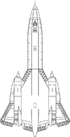
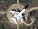
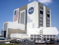
Space base John F. Kennedy - NASA - Military | USA -
[19/09/2006]
Place : Merritt island, Florida.
Description : Canaveral Cape is an American launching base located in Florida that was created in 1959. It is a military zone.
Its administrative name is John F. Kennedy Space Center. This base has the highest travelling tower in the world (377 feet - 115 m).
View on Google Maps |
|
|
|
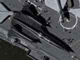
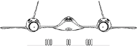
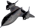
Black Bird A-12 - Military | USA -
[19/09/2006]
Place : New York, New Jersey.
Description : The SR-71 Blackbird was conceived like the successor of Lockheed U-2: an observation aircraft usable to the top of "hostile theatres of operations".
The structure of BlackBird is out of Titanium, whose fusion takes place with 1660 °C, which enables him to reach higher speeds.
Scale :
55,6 feet - 16,94 m
Lenght :
107.4 feet - 32.74 m
Height :
18,5 feet - 5.64 m
Maximum mass :
77100 kg
Maximum speed :
2200 mph- 3532 km/h
Ceiling :
85300 feet - 26000 m
Maximum distance :
2980 miles - 4800 km |
|
View on Google Maps |
|
|
|
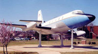
Jetstar VC-140b - Military | USA -
[19/09/2006]
Lieu : Andrews Airforce Base, Morningside, Virginia.
Description : Created in 1957, JetStar transported presidents Nixon, Johnson, Ford and Carter during their displacements. JetStar is the first presidential plane in the United States, called " Air Force One " nowadays.
View on Google Maps |
|
|
|
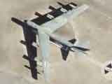
B-52 - Military | USA -
[19/09/2006]
Place : Between Monument and Colorado Spring, Colorado.
Description : First B-52 Bomber flight was in 1952 with the US Air Force. B-52 objective was to carry the American nuclear weapons. It is one of the symbol of the cold war and was in 1952 one of the largest planes in the world.
It was used in the Vietnam and Iraq war. Of a scale of 185 feet (56.39 m) it can reach 593 mph (955 km/h) and can traverse 7450 miles (12000 km) of a feature.
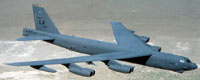
View on Google Maps |
|
|
|
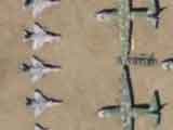
Planes cimetery - Military | USA -
[19/09/2006]
Place : Tucson, Arizona.
Description : This place is a cemetery of planes. There are 2000 planes stored in full desert because of the American disarmament program. These 2000 planes represent half of all the American military fleet and will be able, in the event of war, all to be given in service in only six months. You will notice can be that certain their wings broken and brought back along the fuselage have, it is to show to the Russians via the images made by their satellites that American respects their engagement in term of rate/rhythm of disarmament.
View on Google Maps |
|
|
|
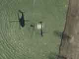
Water bomber helicopter - Military | USA -
[19/09/2006]
Place : Aurora, Colorado.
Description : A water bomber helicopter is a helicopter conceived to fight against the small forest fires and the major fires. The helicopter of this view transports a head of water at the end of a sling (cable hung under the helicopter), one speaks about "bucket" or "bambi bucket".
View on Google Maps |
|
|
|
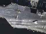
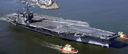
JFK aircraft-Carrier - Military | USA -
[19/09/2006]
Place : Mayport Basin, Jaksonville, Florida.
Description : The aircraft-carrier "John Fitzerald Kennedy" belongs to the U.S. Navy. Appeared in 1964, this nonnuclear aircraft-carrier is always active in 2006.
View on Google Maps |
|
|
|
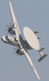
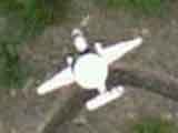
E2 - Hawkeye - Military | USA -
[19/09/2006]
Place : Mugu lagoon, Oxnard, California.
Description : Grumman E-2 Hawkeye is a monitoring plane for any weather any transportable by aircraft carrier that was developed by the American manufacturer Grumman.
E-2 Hawkeye is in working since 1964 and its crew is composed of five men. Apart from the American navy, it is also used by the French Naval Aviation and the Air Forces of Taiwan, Mexico, Israel, Singapore, Japan and Egypt. |
|
View on Google Maps |
|
|
|
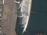
"Charles de Gaulle" aircraft carrier in Toulon - Military | France -
[19/09/2006]
Place : Toulon (83).
Description : Arsenal is the first naval port of France. It is the fastener point of the Charles de Gaulles aircraft carrier that we see on this sight.
This door plane is the only one still in activity in France, the "Charles of Gaulle" is propelled by nuclear energy. This aircraft carrier is 858 feet (261,5 m) long , 211 feet (64,36 m) broad, and 246 feet (75 m) high for a 40600 tons weight.
View on Google Maps |
|
|
|
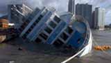
Cruising boat reversed - Strange | South Corea -
[19/09/2006]
Place : Seoul.
Description : The Maemi hurricane in South Korea was the most powerful of these 100 last years in this area. Winds of 135 mph (216 km/h) reverse this cruising boat in the Busan port.
View on Google Maps |
|
|
|
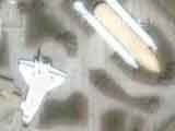
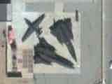
Black Bird (SR-71) - Military | USA -
[19/09/2006]
Place : Palmdale, California.
Description : Blackbird Airpark (AFFTC Museum) is an open museum since 1991. This museum at summer set up in order to preserve the memory of Black Bird, able to reach the speed of 2194 mph (3532 km/h).
View on Google Maps |
|
|
|
|
| |